Monthly Archives: March 2010

Hey, Thatโ€™s Like What They Use on the TV!: The Best Weather Websites on the Web, Miscellaneous Observations

Well, in the past five posts in this series I have reviewed five different weather websites, all of differing qualities (and kind of mixed up orderwise). These sites are useful for pretty much all your weather information needs, weather geek or non-weather geek. I can tell you one thing for sure: whether it’s dryline-induced supercells in the springtime or scattered garden-variety thundershowers early on a summer afternoon, sites like the ones I mentioned are very useful for tracking storms like that and lots of other weather phenomena as well. However, there are a few other sites out there as well that have proven to be valuable tools in my arsenal, too. These sites are more specific than the five I reviewed before, so I’ll be putting them in this “honorable mention” post. After these, there shall be a “strategy guide” to using these sites to track storms and such.

  • Plymouth State Weather Center is a weather site from Plymouth State University in New Hampshire. This site I love for their multitude of useful maps, mostly the radar/satellite images. They also have other stuff like current observations from many areas and forecast models. The NEXRAD products are what I like the most, though: by going to “CONUS & PR Sites” you can access the radar sites around the USA. These are basic maps, yes, but the reason I like them so much is the multitude of products – they have the VIL images for hail size estimations and all kinds of velocity images at different scan levels…wow. And the no-frames site that is offered is very lightweight, making viewing on mobile devices like PSPs and iPod touches, Blackberrys and such easy. Heck, it is still great viewing on the laptop and desktop too!
  • College of DuPage Weather. This weather site, run by the aforementioned college in Glen Ellyn, Illinois, is very much the same kind of site as that of Plymouth State. Great radar products, lightweight site, models, all that good stuff. I absolutely love their 1km state/state region radars, since they tend to show phenomena like outflow boundaries very well, which are critical for local short term forecasts when thunderstorms are scattered around the area on a summer afternoon or something.
  • Meteostar. This fairly obscure general weather site offers the usual airport current conditions and forecasts and local alerts on city/zip lookup. Their radar is basic, but not that shabby looks-wise (believe me, the background land map makes or breaks radars a lot of the time). They also have miscellaneous current conditions and forecast data for local areas as well as regions and the country at large, even having a Google Map for current conditions (once again, only at airports).

    What makes this site notable, in my opinion, are the extraordinary weather maps offered. Seriously, go to Imagery and look at their satellite images. Dang – look at that radar/satellite image! Meteostar’s radar/satellite images are very large and detailed and great to look at.

So there you go: a bunch of weather sites that serve as great (or not-so-great) places to keep up with and track weather in your area, at least here in the United States. Someday in the future I’ll review weather sites in other countries – don’t want to leave you out! ๐Ÿ™‚

Hey, That’s Like What They Use on the TV!: The Best Weather Websites on the Web, Part 5

In the previous posts of this series, I have showcased four websites that provide weather information, each with their unique strengths and weaknesses. I listed my favorite first (the Weather Underground) and am working my way down, though I probably should have switched the order of Weather.com and the National Weather Service site. Oh well. This post will look at another weather website, then the final post (?) of this series will highlight honorable mentions and other useful weather-related resources.

Get yourself ready now, as it’s time to dive into number…

Ah, Accuweather. What can I say about this one…?

Okay, it’s not THAT bad. But its quality is definitely below that of the others, though it does have a couple strong points. Looking up your local area’s weather pulls up your basic airport current conditions, and a forecast for the rest of the day you looked it up and the next one. There are also tabs for a weekend forecast and an extended forecast for 15 days. “Wow,” you must be thinking, “a 15 day forecast?! This site may very well be great!” Well… beyond about 10 days it is pretty much just them filling in whatever is similar to days 6-10. So take that with a grain of salt. ๐Ÿ˜‰ There are also hourly forecasts and such, in line with the other sites I mentioned.

You also get weather news below all that for your region of the country. I have to give Accuweather credit in this aspect: they are great for checking up on weather news and such. They have articles and video, as well as blogs. Also on the page is another neat feature – for major metro areas, video forecasts from Accuweather meteorologists are available. They aren’t local to the regions though, so some of the benefit is lost as far as my opinion goes. Local weather alerts are also highlighted.

After this, though, Accuweather starts to fail, and fail hard. There is a link to a weather radar, which will take you to a state image. You can zoom in to major metro areas also. These radars are fairly basic, though, and only update every 15 minutes That’s different though if you shell out some ยขa$h monthly/yearly for their premium service, which counts against the site heavily as far as these reviews go. While the WU does have premium benefits as well, they are not nearly as ridiculous as Accuweather’s. You’ll see more examples of this as we go through this post. You can also view NEXRAD images, which are just the basic radar data, unless you wanna shell out some bucks for the detailed storm data and plotted paths (hint: they are on the Weather Underground for free). I do have to give credit where credit is due, though: their radar/satellite combo map is straightforward and awesome. They also have some great satellite maps.

On the Severe tab you’ll get an interactive weather warning map (ya know, just like the WU and Intellicast, only more clunky). They also have a variety of forecast maps, which are fair, but not as visually appealing to me as the ones on Intellicast.

Also a little credit for Accuweather: they have an active community in forums, on social networking sites, and so on and so forth. But so does the Weather Underground… ๐Ÿ˜€

Well, after hitting them points, we come to yet another interactive weather map. Here, it’s called MapSpace. There is a regular radar view and a high-res one, but there is nothing in the way of storm data or anything with the images. The high res is kind of neat though…

While this map ain’t nearly as useful as that of the WU or Intellicast for local storm tracking, they do have some good data views for other purposes. They have a really good radar/satellite combo and enhanced satellite as well as radar for the sometimes-neglected Alaska and Hawaii. Also included is a current conditions view like you might get on TV, but there is no clicking for detailed data or anything. MapSpace can’t touch Full Screen or the WunderMap there. Then, there is the lightning strike data. Useful? Only if you can pay to view the strikes close up…

One of the things that really stand out about Accuweather is that they are one of the only American weather sites that includes radar from Europe and Canada, and on MapSpace no less. I mean, you can find that kind of data on sites in the respective countries, but man – that is neat. Gotta give them props for that.

Overall, while Accuweather does have its perks, I don’t use the site very much at all in my weather tracking and monitoring, as it’s fairly mediocre. It ain’t so if you decide to pay (frankly, they offer some neat-ass stuff for the money) but these reviews are about what everyone can see, including those who can’t pay, and Accuweather kinda sucks in that category. Plus, the ads are overwhelming and not well-integrated like those on the WU and Intellicast.

In the next few days, look for some summarizing and some very honorable mentions.

Overall Grade: C-

Hey, That’s Like What They Use on the TV!: The Best Weather Websites on the Web, Part 4

Some say that when you have a government-owned entity in any field, it will tend to be more serious and straightforward. While I believe there are examples and exceptions in that belief, the National Weather Service is an example. Their website is ad-free, fluff-free, serious weather data and information.

The National Weather Service is the official weather analysis and observation organization of the United States Federal Government, and is the backbone/provider for most of the weather data that the other websites use (like radar, forecasts, current conditions [for non-PWS websites], warnings, and more). There is the national office with many departments around the nation as well as local offices for each region of the United States. What you want to do is find your local office and go to their site for local information, using the national site for national analysis and maps. If you’re seeking no-frills maps of the nation to use for making personal forecasts and doing amateur analysis, then the NWS site is where you want to go. It’s a bit hard to navigate because of the sheer amount of data available and confusing site design, but it’s worth it.

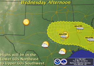
Your local NWS site is a great place to have in your weather website bookmarks. Many offices, like my local office for the Dallas/Fort Worth area in Texas here, offer ‘graphicasts’ that tell you about weather coming your way that you’ll only see on the NWS site, like this one forecasting thunderstorms tomorrow for North Texas:

Graphicasts can be quite useful, as you can see. You can also get forecasts for your local area, often for your neighborhood specifically, by clicking close to where you are on the clickable maps on the local office homepages. Weather warnings, watches, advisories, and outlooks are there, too, of course, but the other weather sites do a good job of displaying them as well (especially the Weather Underground).

There is also a feature called “Graphical Forecasts” (not to be confused with the graphicasts) where you can look at maps of the U.S as well as zoomed-in regions that are basically forecast maps showing everything from precipitation outlooks, to temperature forecasts, and even humidity and wave height. This is a very neat feature as well.

The NWS radars are basic and not that exciting – just the data on a map of your local area, region, or the nation. Nothing more, nothing less. There is no interactive map or anything, though there is one in proposal at the moment which I’ll discuss when it comes out this October or so. Looks like it’ll be on par with that of the Weather Channel at best right now. Other maps are the same way.

Every NWS site has miscellaneous information (like local climate data) and region-specific stuff that is too numerous to list and review here, so I’ll just say to check out your local site as well as the national site and see what they have to offer. The strong points overall would be the graphicasts and local forecasts, as well as the weather maps, forecast maps, and the clean site. Overall, the NWS is a good site to have in your bookmarks. Next up, Accuweather! Then, after that, look for a summary of the weather sites and perhaps a few honorable mentions.

Overall Grade: B+

Of Picking, Choosing, and Religious Wackos

Since I have been going to college, I’ve noticed that my TV viewing has plummeted, especially in the news department. I used to watch the local news almost nightly, but I had fallen off the wagon, and have been ignorant of local happenings for a few months now. I don’t say the same for national and international stories, though, because I read the Huffington Post daily.

Today, however, is a day in the week known as Spring Break, and I am fairly bored, so I figured I’d look at CBS 11’s website and check up on the local goings-on. Lo and behold, I saw a story that captured my eye right from the start:

Dallas Jail Guard Fired Over Anti-Gay Remarks

Ding! Whenever a story comes out about an LGBT topic, I’m tuned in, since I have a personal interest in them. Pretty much, this guy is a religious right wacko who went around claiming that he “disagrees with homosexuality” and that gays should be killed, slavery is justified by the Bible, and other generally ancient and off-the-wall “ideas”. He has a history of racism as well, and claims that dinosaurs are the work of something Satanic (his exact wording was too rambly and wacky for me to really decipher).

What really got me is this little snippet of the story:

“They made it out to be that I was a bigot. I was fired ’cause I hurt someone else’s feelings,” Johnson said Monday. He said that his free speech rights were violated but that he will not appeal.

Wow, where do I start? Well, guess I should start from the beginning. Saying you “disagree with homosexuality” is like saying you “disagree” with being black or being left-handed: it’s saying you don’t like a part of who someone is. It’s a simple fact that being gay is not a choice but is something that occurs in people naturally, as with other animal species.

This guy seems to think that he had the right to say that stuff based on the First Amendment or something. He’s freaking promoting genocide! That is not covered, period, because he is promoting criminal activity against people due to a naturally-occurring trait. Newsflash, guy – you ARE a bigot. Simple as that.

Finally, the part where he claims he was fired because “he hurt someone’s feelings” is really provoking in itself. While he’s going around talking about all this “Christian” belief stuff, he seems to not be aware of one of the Christian principles that he and other religious righties love to ignore – the Golden Rule. Under that rule, which morally applies to *everyone* (not just Christians) he should be treating others the way he wants to be treated. That includes what he calls “hurting someone’s feelings”. Ain’t it amazing how many insensitive pricks there are, Christianity-claiming and otherwise, who seem to ignore a common sense moral like the Golden Rule?

Hey, That’s Like What They Use on the TV!: The Best Weather Websites on the Web, Part 3

So far, we’ve taken a look at two great weather websites: the Weather Underground and Intellicast. Both are great sites, but there are other notable ones out there, too. No weather site is perfect, and it’s pretty good advice to use multiple sites for all their strengths, like the Weather Underground for current conditions and local storm tracking and Intellicast for current conditions maps. There are literally dozens (and perhaps hundreds) of weather sites out there, not even including non-American ones (as a side note, all of the reviews in this series are geared for American audiences. Sometime in the future, I will start reviewing websites for foreign countries as well.)

The thing about it is, out of all those dozens of websites, there are only a small handful that are really worth your time – that offer more than just conditions and a forecast, but really good miscellaneous features. With that, let’s move on to weather website number…

Ah, The Weather Channel. You’d be hard pressed to find anyone in the United States that has not heard of it. The cable and satellite network, launched in May of 1982, has been the source of weather pages for newspapers, current conditions and forecasts for radio stations, and data for local TV stations for years. When the Internet really started taking off in the early 1990s, they jumped on the bandwagon and started a website, known simply as “weather.com”.

So how does weather.com stack up against the Weather Underground and Intellicast?

Well, the homepage is nice and neat, which, as you know by now, is something I give automatic points for. What I like about weather.com is the inclusion of more “weather news” stories then Intellicast and the Weather Underground, though all of them have weather news to some extent. As noted in the WU post, they have blogs from weather professionals. Also neat is how weather.com offers video of everything from the weather news stories to forecasts for specific regions.

Weather.com offers a smorgasbord of weather maps, from radars to current surface (conditions) to “yesterday-today” temperature differences. The maps are all cleanly made and easy on the eyes, like Intellicast’s. As for current conditions when you look up your area, it’s just airports again. Forecasts offered are a ten-day one, hourly, tomorrow, and one for the upcoming weekend. You can also look back on the conditions for the previous day and the days in your current month prior to the day you check it. A neat little widget on the current conditions page gives you a “comfort index” for exercise outdoors, a cool feature.

Below the current conditions for your area is a local radar map, clickable to access the Interactive Weather Map feature weather.com offers. The interactive map offers radar, satellite, a few elements of current conditions (temperature, dew points, etc), and a radar/satellite combo. You can zoom the map and observe local storms and look at your region’s satellite and such, but there really ain’t much to say about this one. It’s fairly mediocre compared to Intellicast’s and does not even come within a hundred miles of the greatness of the Weather Underground’s interactive map. Weather.com also offers this feature called “future radar”, which is supposed to show where storms and precip are gonna be within the next couple hours, but all it does is blur the radar and push the storms in the direction that they were going previously. It’s just clunky and ugly. They do get points for the inclusion of the radar/satellite, though, cause a good product like that is actually rare.

Weather.com offers some sections for things like driving and travel and such, too, but overall there ain’t much to say about this site except that its strong features are video and weather news. For anything else, the Weather Underground and Intellicast, and probably the site(s) I mention in the rest of this series, beat weather.com out. The next post will tackle the more serious and straightforward website of the National Weather Service.

Overall Grade: C+

Hey, Thatโ€™s Like What They Use on the TV!: The Best Weather Websites on the Web, Part 2

In my last post, I introduced the topic of what I think are the best weather websites on the Internet. I described the Weather Underground, what I think is the best site out there. Although I think the WU is pretty much all that’s needed, there are others out there, too. I’ll be looking at another weather site in this post. Without further ado, let’s take a look at number…

Intellicast is another website that has been around for a good while, though it’s a little younger than the Weather Underground. The site is part of the company called Weather Services International, or WSI. For anyone who watches their local weathercasts, it may be familiar. The reason for that is, the company provides weather data and maps to loads of entities, lots of them being TV stations (“let’s go to the WSI radar/satellite view…”). This site has pretty much what you’d expect for an in-depth weather website: current conditions, weather maps, tropical data, etc. It’s also fairly clean with its advertisements, presenting them in a way that does not make the site unbearable.

When you enter your city or ZIP code in the search box, you get current conditions from the local airport, a ten-day forecast, and some miscellaneous other data. Weather maps available for the nation are pretty much what you’d expect: current surface analyses with fronts and radar and such, radar and satellite images, current conditions maps with color shadings, and that kind of fare. I really like the maps on Intellicast, as they are compact yet detailed with very clean presentation. They just look good to me, even though I can’t really put my finger on exactly why. That is pretty much the only area that I think Intellicast beats the Weather Underground; the maps on WU are actually not as visually appealing as Intellicast’s.

Wow. The style the weather systems are drawn in, the inclusion of satellite imagery, and the inclusion of terrain shadings really makes a big difference.

Intellicast also offers local and regional radar views for local storm tracking, but it falls far short of the Weather Underground’s. First of all, the smoothing is kind of rough and blocky, especially on storm edges. While storm paths and storm type icons are included, there is no finding out detailed information about thunderstorms.

Perhaps the biggest feature of Intellicast, like the Weather Underground, is the inclusion of an interactive weather map, which is quite simply called the “Interactive Weather Map” by Intellicast. This map is, of course, Flash-based and very zoom-able, with the land on the map displayed in the style of one of the three options there: a basic gray background, a topo background, or a background composed of aerial satellite (yes, I know that is redundant) images. As for the data you can have on the map, there are quite a few: there’s your weather radar, called “NOWrad”, in either HD or standard format; HD satellite images; current conditions in the form of temperatures, wind, snow cover, sea temperature; and a fire weather index. There is also this really interesting feature called “Road Weather Index”, which will shade different areas where the roads are wet and where they’re icy, which is very useful for commuters.

There are also a few overlays for the map. The first, and most notable, is Titan Storm Tracking. This marks the location of thunderstorms with status markers (storm cell, hail, meso, and tornadic) and paths, but provides no detailed storm data. You can also overlay severe weather warnings of your choice from the drop-down menu next to the overlay check box, overlay recent earthquake locations, current temperatures from airports, data on active tropical systems, and past tropical tracks. Overall, this is a fairly feature-rich map, and has some really useful things that the WU does not have, but for regular old storm tracking WU’s WunderMap and Full Screen blow Intellicast’s Interactive Map out of the water.

In summary, I think Intellicast performs better than the Weather Underground on current conditions maps, and has a couple unique features on its Interactive Map, but has mediocre radars and does not come close to the Weather Underground in terms of current conditions, considering the fact the only data comes from hourly updates from airports and has no data from personal weather stations. Next post, we shall tackle Weather.com, the website of The Weather Channel.

Overall Grade: B+

Hey, That’s Like What They Use on the TV!: The Best Weather Websites on the Web, Part 1

A couple days ago (Wednesday), I woke up and checked the weather conditions via my WeatherBug app on my iPod touch, and I got the very first indication that spring was on its way in North Texas – a severe thunderstorm watch for a line of storms moving in from the west, bringing hail and heavy rain to parts of the area.

Just to fill in the unfamiliar, spring here in North Texas is our stormiest season. Heavy rain, hail, high winds, tornadoes… the chance is always looming over us. For a weather lover like me, it’s awesome to track these storms as well as other weather phenomena. Even if you’re not into the weather as a hobby or an interest, you’ll still need to keep up with what’s going on weatherwise to know how to dress, if you can have that picnic, etc. It used to be that you’d depend on the TV, newspaper, and radio for weather information. Those tools are still around and still quite useful (maybe excluding the newspaper) for keeping yourself informed, but the advent of weather info on the Internet as well as the advancement of technology in the field of meteorology itself in the 1990s has provided a host of resources that people can use to keep track of their local weather conditions, weather geek or not. And let’s face it – if you’re into the weather like I am, it’s pretty awesome tracking storms with some of these sites! To view screenshots full size, click on them.

Without further ado, let’s start taking a look at some of the best weather sites on the Internet!

Launched in 1995 at the University of Michigan, under a name that serves as a tongue-in-cheek reference to an American communist organization in the 1960s and 70s that originated at the same university, the Weather Underground has become what I consider the best weather website on the Internet.
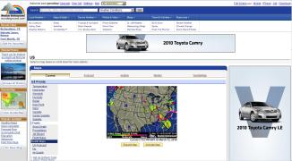
The site is very clean and not cluttered, which I give points for right away, as there are some weather sites out there that are a mess and a half. The maps available on the site are very diverse, as you can see in the above screenshot of the homepage. While most other sites rely on airport weather stations that report once an hour, the Weather Underground jumps feet above them by taking advantage of a worldwide network of personal weather stations operated by businesses, schools, organizations, and even individuals and families, meaning that you can get the current temperature and conditions closer to home. They still include the airport stations, though, as well as a network of hourly stations operated by the U.S. National Weather Service (MADIS). Also worth noting is that the conditions from PWSes are live. Yes, you heard me right: live. Considering these two strong points, they can become quite useful if, say, there are scattered summer storms around your area (which happens quite often here in North Texas) and you get an update from a PWS that the storm went over after it missed the airport.

When you look up your zip code or city/town, you get heaps of useful data, presented in a very organized way. You have your current conditions from the closest weather station, be it an airport, a MADIS station, or a PWS. Chances are, it’ll be a PWS. As I said in the previous paragraph, PWSes are live, so if there is one reasonably close to your location, it’s best to pick that one. You also get your 7 day forecast, air quality info, data from nearby airports, astronomy information (sunrise time and sunset time and such), nearby WU user blogs (more on that later), any alerts for your area, and, below that, an extensive table with live current conditions from stations around your local area other than the one presented at the top.

Linked to from the current conditions page is the NEXRAD weather radar for your area, if you’re in the U.S. that is.

The most shiny star of the Weather Underground, however, is the recently launched Full Screen Mode. It’s both linked to from the WU site and also has its own redirecting URL. Full Screen Mode displays your live current conditions in the bottom left corner and a huge weather map fills the rest of your browser window. This map is Flash-based and loaded with features. What kind of data can you display on it? Well, let’s list a few f them:

* The way the map loads at first has temperatures where weather stations are, with you having the option to click on each for detailed conditions. As you zoom in closer, more will appear. Unfortunately, although a lot of the data itself is live, the bubbles that pop up when you click for more info do not update live, so it will be necessary to refresh to update this data. The icons are plain temperatures at first, but via Settings you can change these to be temperatures with wind barbs, dew point and humidity, and precipitation amounts (very useful after heavy storms).

* There is also an option to display satellite via the “Clouds” button. Via Settings you can opt for infrared satellite or visible. Infrared works day and night, visible only during the day. Visible is the best option, since it’s basically a picture from space of the clouds.

* The star feature of this mode is the NEXRAD radar. FSW allows you to zoom in to street level with the radar or view the storms in the big picture. Be sure you enable smoothing in Settings, though, so you can get a nice (and, well, smooth) view of the precip you’re looking at. Also very well worth noting is the storm tracks feature. Enable that in Settilngs and you’ll get every thunderstorm on the radar labeled and its forecast movement for the next hour shown. The icon on the storm will be a yellow circle for a regular storm, a yellow square for a hail-making storm ,a yellow diamond for a mesocyclonic (rotating) storm, and an upside-down purple triangle for a tornadic storm. Click on this icon and you’ll get some very useful data on the storm, such as max hail size and chance of hail. Definitely very useful if you want to know if you need to move your car under the carport/in the garage in preparation for the storm heading for your neighborhood. Try combining use of the current conditions mode and the radar to get live conditions from areas getting affected by the storm.
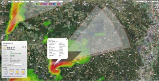
* Last, but not least, there is the Webcams option under “More…”. Quite simply, it puts the locations of weather cameras on the map that you can view.

So there you go, perhaps the neatest feature on the site. The WU also has the older WunderMap feature, basically this without being full screen.

The WU also has lots of other data, but since I want to keep this review concise (or perhaps it’s already too late for that…) I’ll go over them in brief. There is the Tropical section with data, maps, and satellite views of current tropical storms and hurricanes, a large number of weather blogs from both experts and amateurs, member-submitted photos, a road trip planner, and there are lots of minutiae that would take me ages to list in full.

In short, the WU is the best weather site on the internet (at least in my opinion) and it should be a necessity for weather geeks and non weather geek alike!

In the next post, I’ll discuss Intellicast, also a fairly awesome site.

Overall Grade: A